
-Weather elements: These are things you might be told to expect on a weather report
e.g. Rain, hail, sun, cloud, wind, snow, fog, mist, haze, gale, frost
Sun and Seasons
-All weather results from the troposphere, layer from 0-16km altitude
-Source of energy, wind blowing and temperatures, is the sun
-Solar energy is not evenly distributed
-Material, colour and elevation also affect energy storage and release, changing weather and climate

-Equinox is equal number of day and night hours (spring and autumn)
-Solstice is when there are the longest or shortest daylight hours (summer and winter)
-Latitude at equator is at 0 degrees
-Latitude at poles is 90 degrees
-Higher latitude = less solar energy
Air masses
-An air mass is a body of air with similar temperature and moisture levels, which influence the weather of areas it travels through
-Continental air masses have travelled over land
-Maritime air masses have travelled over oceans
-Warm air can hold more moisture than cold air
Tropical: Hot, originating in or near the tropics
Polar: Cold, Origination from or near the poles
Maritime: Moist, origination over an ocean
Continental: Dry, originating over land
Equatorial: Influences northern Aus in summer
Tropical Maritime: Warm and moist, Very warm and moist, influences Pacific/Indian ocean coasts summer thunderstorms to SA and Vic, and heavy rain along east coast
Tropical continental: Hot and dry, hot, dusty conditions in southern Aus
Southern Maritime: Cool and moist, common in southern Aus all year
Polar maritime: Cold and moist, coldest winter weather and >800m snow in SE Aus occasionally
-Southern Maritime has the greatest influence on Vic


Air Pressure
-The force exerted by the weight of air particles
-Rising and falling air pressure generates wind, cloud, cold, wet, fine, and sunny conditions
-Climate is about long term record, trends and averages; weather is the day to day experience
-Regions of sinking air = highs, high pressure regions, anticyclones
-Regions of rising air = lows, low pressure regions, depressions, cyclones
-Isobar = line used on weather maps which pass through areas with the same air pressure
-Air pressure measured in hectopascals (hPa)
High pressure:
-value of isobars increase toward centre
-air expands
-air is sinking
-air becomes warm and stable
-air spirals outwards
-in a anticlockwise direction
-cover a greater area
-move more slowly
-causes dry, cloud-free weather
Low pressure:
-value of isobars decrease toward centre
-air contracts
-air is rising
-air spirals inwards
-air cools to form clouds
-in a clockwise direction
-cover less area
-mover more quickly
-causes rain showers and cloudy weather
-Cold fronts represent line where col polar air meets warm tropical air
-Temperature difference creates strong winds (air moving to spread/even out)
-Cold air pushes warm air up
-Rising warm air can produce clouds
-71% of the Earth’s surface is water
Clouds
-a cloud is a swirling mass of water vapour
Type Level Appearance Precipitation
Cirrus High high level, white tufts or filaments; made up of ice crystals. No precipitation
Cirrocumulus High small rippled elements; ice crystals No precipitation
Cirrostratus High transparent sheet or veil, halo phenomena; ice crystals No precipitation
Altocumulus Middle layered cloud, rippled elements, generally white with some shading. May produce light showers
Altostratus Middle grey sheet, thinner layer allows sun to appear as through ground glass. Rain or snow
Nimbostratus Low thicker, darker and lower based sheet. Heavier intensity rain or snow
Stratocumulus Low layered cloud, series of rounded rolls, generally white. Drizzle
Stratus Low mass, grey, uniform base; if ragged, referred to as "fractostratus". Drizzle
Cumulus Low individual cells, vertical rolls or towers, flat base. Showers of rain or snow
Cumulonimbus Low-High very large cauliflower-shaped towers to 16 km high, often "anvil tops". Phenomena: thunderstorms, lightning, squalls. Showers of rain or snow
-Cirrus = curl of hair = wispy, high altitude
-Alto = middle = mid-altitude
-Nimbus = rain = raincloud
-Stratus = layer = sheet-like
-Cumulus = heap = puffy clouds
-Cumulonimbus = thunderclouds (summer storms etc)
Weather maps/Synoptic charts
-Summarises the state of the atmosphere at a particular period of time
-Air pressure measured at selected locations
-Isobars are drawn at 2 hectopascal intervals
-Isobars connect places with equal air pressure
e.g. ------- 126 --------
-When looking for pressure of an area, look for nearby pressure systems which enclose the area
-cool air descends to create high pressure, and cannot rise due to pressure of descending air from above, nor descend any further. So, it flows along the earth’s surface as wind and travels toward a low pressure system to replace heated rising air
-Rotation of earth drags wind of a straight line course
-Closer the isobars, stronger the wind
-Winds named after direction from which they blow, i.e. southerly wind head north
-Wind direction shown by symbol
-Barbs on tail of symbol indicate speed
-areas with rain in the last 24hrs are shaded in parallel diagonal lines
-lows and fronts associated with rising, cooling air
-produces showers or rain
-highs associated with sinking, warming air which retains moisture
-skies generally clearer, fine weather
-winds blowing off the sea often bring rain
-winds blowing from central Aus usually bring dry conditions
Determining temperatures
-After a cold front passes, temperature falls
-Southerly winds bring colder weather
-Winds from the north bring warmer weather
-Graph may be used
Glossary
Weather: The atmospheric condition for a brief period of time; the day to day experience
Climate: The atmospheric condition for a long period of time, approximately 30 years. It is a synthesis of all weather over time and is based on records, trends and averages
Air pressure: The force exerted by tiny air particles, the rises and falls of which generate weather conditions
High pressure: regions of sinking air which spirals outwards in an anticlockwise direction. High pressure is associated with dry, cloud-free weather
Low pressure: Region of rising air which spirals inwards in a clockwise direction. Low pressure is associated with rain and showers
Isobars: The lines on a weather map which pass through areas of equal pressure
Cold front: represents the line where cold polar air moving toward the equator meets warm tropical air moving pole ward
Relief (Orographic) rainfall:
1. Warm moist air cools as it is forced to rise by mountains and hills
2. Cool air condensed to form clouds
3. Precipitation falls
4. Drier air warms up as it descends the mountain/hill, producing less rain, known as a rain shadow

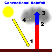
Convectional rainfall:
1. Air is warmed by the sun
2. Warm air expands as it rises
3. Cooler air condenses, forms clouds
4. Heavy rain is produced and falls
Frontal rainfall:
1. Cool, denser air of a low pressure system moves across earth’s surface
2. Warm, lighter air is forced to rise as the cold front moves in
3. Air is cooled, condenses, and can cause rain to fall

No comments:
Post a Comment